West Bosque-Central Ave. to Bridge St. Hike
In Albuquerque Region
Map File Source: DeLorme
 Hike Key: H10581
Last Updated: 12/15/2020 12:00am
Last Updated By: Marilyn Warrant
Hike Class: A (Easy)
Hike Distance: 4.3 mi
Minimum Elevation: 4929 ft
Elevation Change: 12 ft
Total Uphill: 20 ft
Total Downhill: 20 ft
Avg. Grade: 0 %
Route Type: InOut
On Trail: Yes
Paved or Gravel Roads: Yes
GPS Advised: No
Drive Distance Round Trip: 20 mi
Drive Time One-Way: 0:30
Hiking Seasons: Spring, Summer, Fall, and Winter
New Mexico Game Unit: 9
Hike Status: Published
Highlights
This trail has several foot bridges to the Rio Grande overlooks, and a boardwalk with several benches.
CautionsNone.
Trailhead DirectionsI-40 to Rio Grande Bd. south to Central Ave. then west over the Rio Grande bridge. Make first left after the bridge and park in the open area to the left.
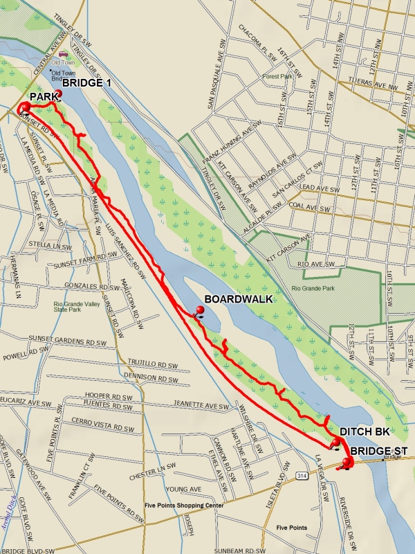
Actual HikeFrom PARK (0.0 mi) hike east toward river and go south through the fence access at the Rio Grande Valley State Park sign. Follow the well-defined trail past BRIDGE 1 (0.2 mi), which is the first of 4 foot bridges that lead to river overlooks. Continue past BOARDWALK (1.2 mi) to BRIDGE ST. (2.3 mi). To return, hike north and then west to the ditch bank at DITCH BK (2.55 mi) and then north to PARK.
CommentsThis trail connects with the Silvery Minnow Habitat hike to the south. There are many good restaurants in the area like the Shark Reef Cafe at the city acquarium.
WaypointsPARK: N35 05.221, W106 40.934
BRIDGE 1: N35 05.263, W106 40.817
BOARDWALK: N35 04.615, W106 40.297
BRIDGE ST: N35 04.160, W106 39.761
DITCH BK: N35 04.218: W106 39.798
Hike GPS File Name: WestBosque-CentralAveToBridgeSt_FE.gpx
Hike GPS File: Click link to download hike waytrack file
Text Author: Frank Ernst
Map Author: Marilyn Warrant
Waypoints Author: Frank Ernst
Track Author: Frank Ernst
Maintainer: Frank Ernst
Editor: Howard Carr