Taylor Ranch Trails Hike
In Albuquerque Region
Map File Source: DeLorme
 Hike Key: H10528
Last Updated: 12/15/2020 12:00am
Last Updated By: Marilyn Warrant
Hike Class: B (Moderate)
Hike Distance: 5.6 mi
Minimum Elevation: 5122 ft
Elevation Change: 80 ft
Total Uphill: 90 ft
Total Downhill: 90 ft
Avg. Grade: 1 %
Route Type: Messy
On Trail: Yes
Paved or Gravel Roads: Yes
GPS Advised: No
Drive Distance Round Trip: 26 mi
Drive Time One-Way: 0:15
Hiking Seasons: Spring and Winter
New Mexico Game Unit: 9
Hike Status: Published
Highlights
Explore two major arroyos in Taylor Ranch, Mariposa and Boca Negra.
CautionsNone.
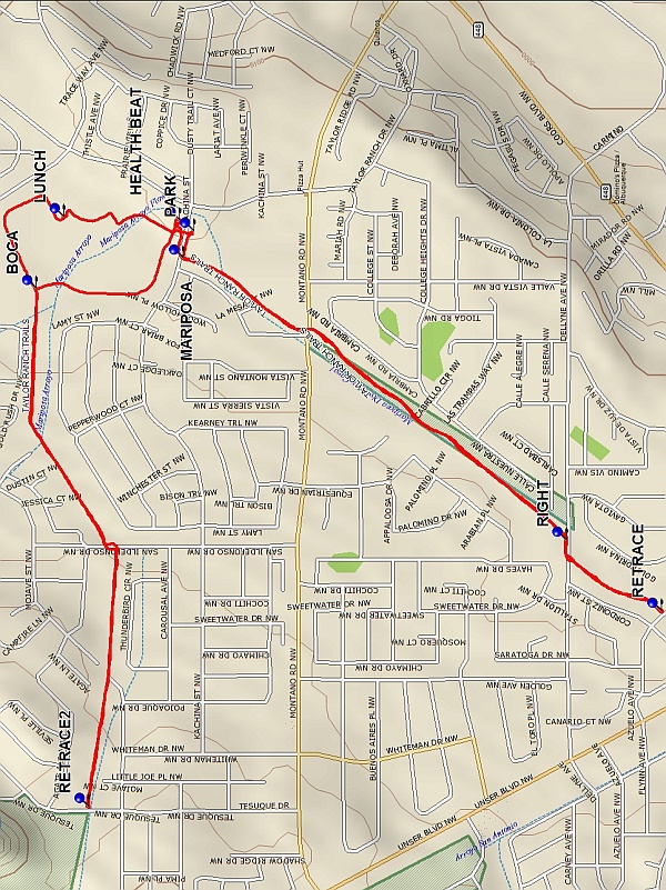
Trailhead DirectionsFrom I 40 take Coors Blvd. north to Montano. Turn west (left) on Montano and then north (right) at Taylor Ranch Blvd. Turn west (left) at the first traffic light onto Kachina and then left into the Taylor Ranch Community Center and PARK. The center offers an opportunity to use bathrooms before and after the hike.
Actual HikeWalk to Kachina and west to the MARIPOSA bike trail. Turn left and follow the Mariposa Arroyo southwest for 1 mile. At Dellyne turn RIGHT and cross a bridge; the bike trail continues on the opposite side of the arroyo. Follow the trail another .3 mile or so then RETRACE the route to Kachina. Cross the street diagonally and stop at HEALTH BEAT to use the exercise equipment. Continue by walking clockwise around the Mariposa Basin Park to BOCA. Bear left and follow the bike trail along the Boca Negra Arroyo until it ends at Tesuque Drive. From there you can see Boca Negra Canyon. Turn around at RETRACE2. On reaching BOCA bear left and continue around the Mariposa Basin Park trail until it bears right and heads down toward LUNCH. This is a good lunch spot and an opportunity to see lots of mallards and widgeons. After lunch, continue on through the parking lot and back to PARK.
CommentsThis cool weather hike explores two major arroyos in the Taylor Ranch neighborhood, Mariposa and Boca Negra. The bike trails pass houses both simple and snazzy. The Mariposa Basin Park features playing fields, picnic tables, the HealthBeat facility and two ponds frequented by ducks and geese.
WaypointsPARK: N35 09.341, W106 41.705
MARIPOSA: N35 09.358, W106 41.758
RIGHT: N35 08.730, W106 42.323
RETRACE: N35 08.576, W106 42.465
HEALTH BEAT: N35 09.364, W106 41.682
BOCA: N35 09.598, W106 41.819
RETRACE2: N35 09.513, W106 42.856
LUNCH: N35 09.554, W106 41.676
Hike GPS File Name: TaylorRanchTrailsWayTrack_BS.gpx
Hike GPS File: Click link to download hike waytrack file
Text Author: Judie Schwartz
Map Author: Marilyn Warrant
Waypoints Author: Bob Schwartz
Track Author: Bob Schwartz
Maintainer: Not Assigned
Editor: Marilyn Warrant