El Cerro de Los Lunas Hike
In Los Lunas Region
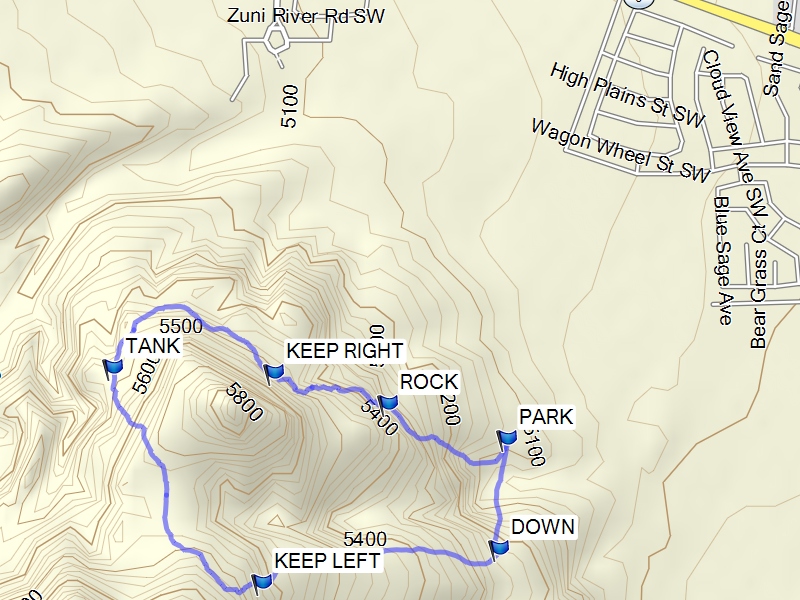
Map File Source: Garmin BaseCamp
 Hike Key: H10508
Last Updated: 12/15/2020 12:00am
Last Updated By: Marilyn Warrant
Hike Class: B (Moderate)
Hike Distance: 4.7 mi
Minimum Elevation: 5061 ft
Elevation Change: 643 ft
Total Uphill: 756 ft
Total Downhill: 756 ft
Avg. Grade: 11 %
Route Type: CCW Loop
On Trail:
Paved or Gravel Roads:
GPS Advised:
Drive Distance Round Trip: 52 mi
Drive Time One-Way: 0:30
Hiking Seasons: Spring and Fall
New Mexico Game Unit: 13
Hike Status: Inactive
Highlights
Excellent views of the ridge of the West side of the Rio Grande rift, the Isleta volcano and the Sandias, and the full western face of the Manzanos.
CautionsNone.
Trailhead DirectionsSouth on I-25 to Los Lunas Exit (203), West (right) on NM 6 to second access of Hunning Ranch Loop SW, about 1.1 miles. Go left past school to dead end at Lonestar, (1.1 miles) then right up the hill to stop sign, left in undeveloped sub division to next right, take the right turn to stop sign, then left to what will be a cul de sac and PARK. Trail head is at SE part of circular drive. IMPORTANT: To see the subdivision with the streets mentioned above, look under GPS Files and use the “Click here to see waytrack on satellite image.” Once on the page, click the + to enlarge the image so you can see all the street names.
Actual HikeYou should do this hike in the counter clockwise direction as the high sandy area is best done returning downhill. From PARK (0.0 mi), go about 20 yards and turn up the right trail. When you come to ROCK (0.3 mi) continue straight. At the fork KEEP RIGHT (0.6 mi), take the right fork. As you approach TANK (1.1 mi), take the alternate path (very faint at beginning) up the slope and through the saddle between the two volcanoes. Bear to the left at KEEP LEFT (1.7 mi). On the far side of the saddle, the main trail is rejoined. Continue down slope to DOWN (2.3 mi) and go left, returning to PARK.
CommentsSet Inactive because hike has been closed by the Los Lunas Open Space.
Excellent views to the NW showing the ridge of the West side of the Rio Grande rift, NE with Isleta volcano in the mid distance and the Sandia’s behind in the distance, and to the SE with the full western face of the Manzano’s. There are volcanic rocks on the trail and places of deep sand. The route of this hike utilizes the saddle between the two Los Lunas volcano’s which appear from a distance as one. This hike is under further development by the Village of Los Lunas Open Space. They are planning an eight mile hike to encompass both volcanic deposits. Currently, the trailhead is for autos only which makes this a car pool hike. There are plans for van parking to be added. Signage for the hike is also planned.
WaypointsPark N34 48.409 W 106 47.022
Rock N34 48.468 W 106 47.281
Keep Right N34 48.521 W 106 47.528
Tank N34 48.528 W 106 47.875
Keep Left N34 48.158 W 106 47.550
Down N34 48.298 W 106 47.037
Hike GPS File Name: ElCerroDeLosLunasWayTrack_BG.gpx
Hike GPS File: Click link to download hike waytrack file
Text Author: Theodore (Ted) Cooley
Map Author: Marilyn Warrant
Waypoints Author: Bill Gloyd
Track Author: Bill Gloyd
Maintainer: Not Assigned
Editor: Howard Carr