Winsor Ridge – Stewart Lake – Winsor Creek Hike
In Pecos Region
Map File Source: NG Topo
 Hike Key: H10495
Last Updated: 12/15/2020 12:00am
Last Updated By: Marilyn Warrant
Hike Class: D (Difficult)
Hike Distance: 9.8 mi
Minimum Elevation: 8140 ft
Elevation Change: 2045 ft
Total Uphill: 2170 ft
Total Downhill: 1890 ft
Avg. Grade: 10 %
Route Type: CCW Loop
On Trail: No
Paved or Gravel Roads: Yes
GPS Advised: No
Hiker Limit (NF/BLM/NP): 15 (Pecos Wilderness)
Drive Distance Round Trip: 200 mi
Drive Time One-Way: 2:00
Hiking Seasons: Summer and Fall
New Mexico Game Unit: 45
Hike Status: Published
Highlights
A strenuous hike in the woods with lush wildflowers along the trail, as well as at the lake. Conifers & aspens. Uphill ridge trail with views, downhill trail with views of Winsor Creek.
CautionsSteep (12% grade) downhill. Hiking poles recommended. High altitude; not recommended for hikers with respiratory disorders.
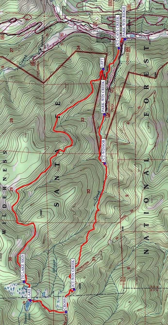
Trailhead DirectionsFrom Albuquerque, go north on I-25 to Exit 299 Glorieta. Cross over the highway, turn right onto NM 50, and travel 6 mi to the town of Pecos and a junction with NM 63. Turn left, and proceed 20.2 mi to Cowles. For a shuttle hike, drop off the hikers at the intersection with FR-121. Drive the vans down FR-121 about 1.2 mi to the Winsor Creek trailhead, leave one van, and drive the other back to the hikers and PARK.
Actual HikeFrom PARK-WIN RIDGE, start hiking on the Winsor Ridge trail which goes steadily uphill. Pass the JCT-CAVE CREEK (0.2 mi). At the next trail junction, go LEFT (1.0 mi). Continue hiking uphill through the forest. Depending on your start time and how fast your group hikes uphill, you may want to eat lunch before you come to the TO LAKE SIGN (5.6 mi) and the LAKE (6.0 mi). Otherwise, eat lunch at the lake. The trail continues downhill past a stream CROSSing (6.6 mi) to the JCT-WIN CREEK (7.0 mi). Take that trail which is steep with downed trees and is no longer maintained but is much shorter than the Winsor Trail option. You’ll run into the Winsor Trail at JCT-WINSOR (9.1 mi) further down the trail. Continue on to the Winsor Creek trailhead at PARK-WIN CREEK (9.8 mi). If you’ve arranged a shuttle you can start driving home from here. Otherwise, the drivers (and perhaps also the rest of the hikers) have another 1.2 mi walk down the road back to the van, making it an E hike.
CommentsTHIS HIKE WILL RETURN LATE. This is a long hike, so allow plenty of time.
The elevation data were obtained from a track recorded on a Garmin 64st.
WaypointsPARK-WIN RIDGE: N35 48.712, W105 39.601
JCT-CAVE CREEK: N35 48.787, W105 39.734 (0.2 mi)
LEFT: N35 48.976, W105 40.043 (1.0 mi)
TO LAKE SIGN: N35 49.936, W105 43.183 (5.6 mi)
LAKE: N35 49.856, W105 43.457 (6.0 mi)
CROSS: N35 49.428, W105 43.628 (6.6 mi)
JCT-WIN CREEK: N35 49.327, W105 43.298 (7.0 mi)
JCT-WINSOR: N35 48.958, W105 41.438 (9.1 mi)
PARK-WIN CREEK: N35 48.965, W105 40.715 (9.8 mi)
DQ: N35 34.509, W105 41.763
Map Filename: WinsorRidge-StewartLake-WinsorCreekMap3_MW.jpgHike GPS File Name: WinsorRidge-StewartLake-WinsorCreek_DM.gpx
Hike GPS File: Click link to download hike waytrack file
Text Author: Marilyn Warrant
Map Author: Marilyn Warrant
Waypoints Author: Marilyn Warrant
Track Author: Debbie Manoogian
Maintainer: Marilyn Warrant
Editor: Dawn McIntyre