Ellis – 10K Loop Hike
In Sandia Mountain East Region
Map File Source: DeLorme
 Hike Key: H10485
Last Updated: 12/15/2020 12:00am
Last Updated By: Marilyn Warrant
Hike Class: C (Challenging)
Hike Distance: 4.9 mi
Minimum Elevation: 9650 ft
Elevation Change: 645 ft
Total Uphill: 850 ft
Total Downhill: 850 ft
Avg. Grade: 8 %
Route Type: CW Loop
On Trail: Yes
Paved or Gravel Roads: Yes
GPS Advised: No
Drive Distance Round Trip: 60 mi
Drive Time One-Way: 1:00
Hiking Seasons: Spring, Summer, and Fall
New Mexico Game Unit: 8
Hike Status: Published
Highlights
Beautiful foliage color on the Ellis segment in the fall.
CautionsNone.
Trailhead DirectionsFrom Albuquerque go east on I-40 to the SR 14 exit and go north to Cedar Crest. At SR 536 turn left and go up the crest road 11.7 miles to The Ellis Trailhead PARK on your left. A three dollar fee or Golden Age Pass is required.
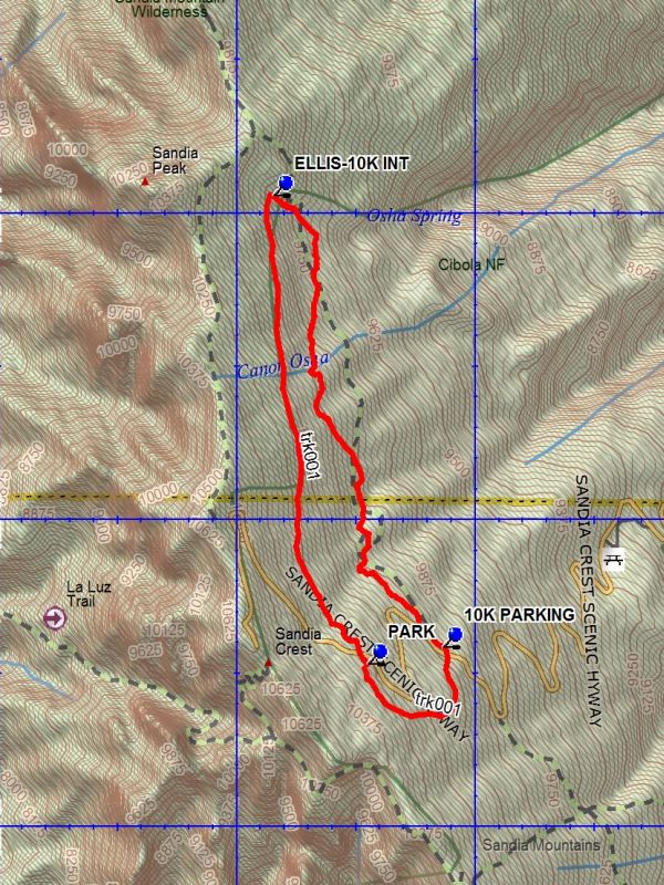
Actual HikeFrom PARK (0.0 mi) go north, crossing the highway. The hike follows the cutting for a road intended to go to the Sandia North Peak area. The road was never completed. The trail intersects the 10 K TRAIL after up and down travel. Turn right onto the 10K trail which goes down steeply to OSHA (2.2 mi). Do not take that downward trail. The 10K trail goes south with a number of ascents and descents until 10K PARKING (4.3 mi). Cross the road and take the footbridge. After ascending the rise leave the 10K Trail and take the trail upward. The trail will continue to rise until Ellis parking is reached.
CommentsA good hot summer hike. Some foliage color on the Ellis segment in the fall.
WaypointsPARK: N35 12.506, W106 26.452
ELLIS-10K INT: N35 14.059, W106 26.857
OSHA: N35 13.957, W106 26.653
10K PARKING: N35 12.594, W106 26.138
Hike GPS File Name: Ellis-10KLoopWayTrack_DBDB.gpx
Hike GPS File: Click link to download hike waytrack file
Text Author: Dick Brown
Map Author: Dick Brown
Waypoints Author: Dick Brown
Track Author: Dick Brown
Maintainer: Not Assigned
Editor: Howard Carr