Mesa Penistaja Outer Loop Hike
In Cuba Region
Map File Source: DeLorme
 Hike Key: H10464
Last Updated: 12/15/2020 12:00am
Last Updated By: Marilyn Warrant
Hike Class: C (Challenging)
Hike Distance: 6.6 mi
Minimum Elevation: 6950 ft
Elevation Change: 250 ft
Total Uphill: 480 ft
Total Downhill: 480 ft
Avg. Grade: 5 %
Route Type: CW Loop
Protected: Yes
On Trail: No
Paved or Gravel Roads: No
GPS Advised: Yes
Drive Distance Round Trip: 190 mi
Drive Time One-Way: 1:45
Hiking Seasons: Spring and Fall
New Mexico Game Unit: 7
Hike Status: Published
Highlights
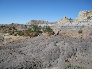
Numerous badlands formations, an arroyo with mostly white rock and numerous pieces of petrified wood. A very large box canyon with petrified wood and spires on the surrounding sides.
CautionsThis hike is off trail over sometimes rough terrain.
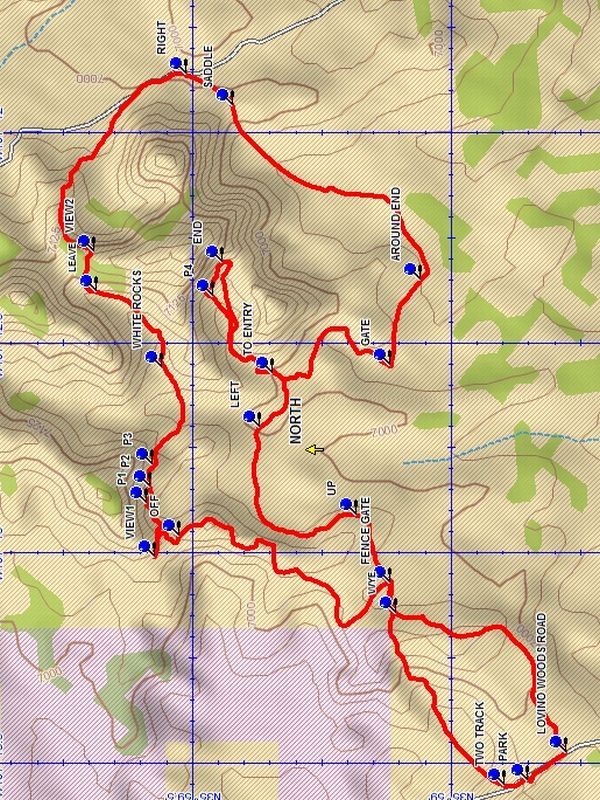
Trailhead DirectionsFrom Albuquerque take I-25 north to Bernalillo. At Bernalillo take US 550 west to the intersection with SR 197 in Cuba. Turn left and drive 9 miles to the DIRT road at the bend in SR 197. Turn right onto the dirt road which immediately turns left and heads west. Drive 7.2 miles to LOVINO WOODS road on the right. Turn right and go 1.7 miles to a two track on the left side of the road. PARK (0.0 mi) here.
Actual HikeWalk north on the road to a TWO TRACK (0.1 mi) on the right and go right. Follow this two track up to the ridge to the east and on to the FENCE GATE (0.6 mi). Go through the fence gate and go northwest along the fence to an edge and go north along the edge to OFF (1.3 mi) and descend to the area below. Continue north until blocked by a mesa and go west to VIEW1 (1.5 mi). Then return and go west along the bottom of the mesa to the north and enjoy P1 (1.6 mi), P2 (1.6 mi), and P3 (1.7 mi). After P3 go over a small ridge and descend into a wash and follow the wash to a main wash at WHITE ROCKS (2.0 mi) and turn left up this wash which is lined with white boulders. The wash will narrow, exit right at LEAVE (2.2 mi) and go uphill to VIEW2 (2.3 mi) with a nice view to the south and a good possibility for lunch.Then go left along the ridge and descend to the floor below and go south to a road. Go right on the road to RIGHT (2.9 mi) where you leave the road and cross over the SADDLE (3.0 mi) to a new floor. As you proceed there will be views to the right of spires and the “Castle”. Head for the end of a low black badlands formation and go AROUND END (3.7 mi) into a WASH heading north to GATE (3.9 mi). Pass through the gate and follow the wash TO ENTRY (4.3 mi) which winds eastward and narrows until a dead end canyon is entered. High cliffs and formations surround as you proceed on the left side where there is P4 (4.5 mi). At the dead END (4.6 mi) turn back, dropping into the bottom and return and exit the box canyon. Turn north up the wash and go LEFT (5.2 mi) up a side wash until the low cliff you came in on is encountered and bear left along the bottom of the low cliff and find a way UP (5.6 mi) and on to the FENCE GATE (5.9 mi). Go through the FENCE GATE and follow the two track west to the WYE (5.9 mi) and keep left continuing to LOVINO WOODS ROAD (6.5 mi) and turn right and follow the road to parking.
CommentsThis hike is off trail over sometimes rough terrain. Use of a GPS when leading this hike is recommended.
WaypointsDIRT: N 35 57.382, W 107 05.520
LOVINO WOODS: N 35 57.424, W 107 13.180
SR197: N 36 00.674, W 106 58.120
PARK: N 35 58.852, W 107 13.544
TWO TRACK: N 35 58.899, W 107 13.554
FENCE GATE: N 35 59.119, W 107 13.071
OFF: N 35 59.526, W 107 12.960
VIEW1: N 35 59.573, W 107 13.011
P1: N 35 59.589, W 107 12.881
P2: N 35 59.584, W 107 12.844
P3: N 35 59.579, W 107 12.789
WHITE ROCKS: N 35 59.561, W 107 12.558
LEAVE: N 35 59.686, W 107 12.379
VIEW2: N 35 59.691, W 107 12.282
RIGHT: N 35 59.513, W 107 11.861
SADDLE: N 35 59.422, W 107 11.935
AROUND END: N 35 59.059, W 107 12.350
GATE: N 35 59.118, W 107 12.555
TO ENTRY: N 35 59.347, W 107 12.573
P4: N 35 59.461, W 107 12.390
END: N 35 59.443, W 107 12.309
LEFT: N 35 59.371, W 107 12.701
UP: N 35 59.185, W 107 12.912
WYE: N 35 59.107, W 107 13.145
LOVINO WOODS ROAD: N 35 58.779, W 107 13.476
Hike GPS File Name: MesaPenistajaOuterLoopWayTrack_DBDB.gpx
Hike GPS File: Click link to download hike waytrack file
Text Author: Dick Brown
Map Author: Dick Brown
Waypoints Author: Dick Brown
Track Author: Dick Brown
Maintainer: John Cooper
Editor: Howard Carr