Valles Caldera National Preserve – La Garita Hike
In Jemez Mountains Region
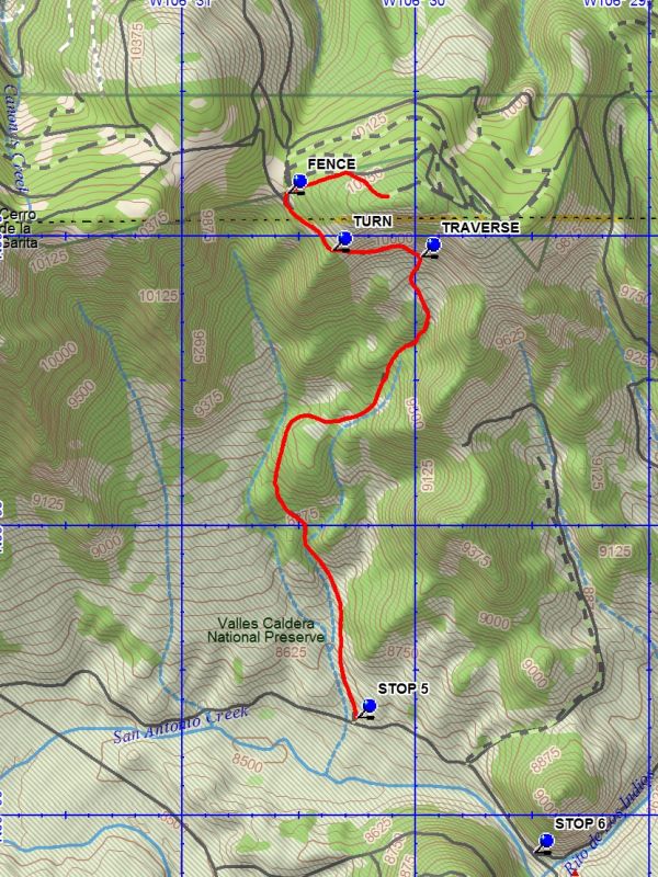
Map File Source: DeLorme
 Hike Key: H10441
Last Updated: 03/19/2021 12:00am
Last Updated By: Marilyn Fixer
Hike Class: D (Difficult)
Hike Distance: 7.5 mi
Minimum Elevation: 8560 ft
Elevation Change: 1530 ft
Total Uphill: 1625 ft
Total Downhill: 1625 ft
Avg. Grade: 10 %
Route Type: InOut
On Trail: Yes
Paved or Gravel Roads: Yes
GPS Advised: Yes
Drive Distance Round Trip: 200 mi
Drive Time One-Way: 2:45
Hiking Seasons: Spring, Summer, and Fall
New Mexico Game Unit: 6B
Hike Status: Inactive
Access Description: Valles Caldera North Access
Highlights
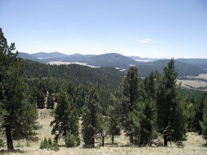
Hike the northern part of the Caldera to extensive views of the area.
CautionsIn the Las Conchas burn scar.
Trailhead DirectionsTake I-25 North and Exit on to Highway 550 (Farmington Highway – old Hwy 44). In San Ysidro, take Hwy 4 to Jemez Pueblo and Jemez Springs. Follow Highway 4 at fork at La Cueva (stay right). The Valles Caldera Preserve is about 22 miles from Jemez Springs. Look for the Main Gate at Mile Marker 39.2. Go to the departure point and take the North Rim shuttle route to stop 5. Travel time includes the time it takes to get to Shuttle stop 5.
Actual HikeThe hike starts at North Rim shuttle stop 5. It is possible to drive up the road for .5 mile to 1 mile to reduce the length of the hike. At the TRAVERSE (2.3 mi) point to the TURN (2.7 mi) there will be excellent views of the entire caldera below. At the turn point your elevation will be about 10,100 feet. Beyond that point and upward along the fence the path to the top is currently estimated.
CommentsGarita can be interpreted to mean gateway (the north gateway to Valles Caldera). Check the Valles Caldera website for current information.
This hike should be checked out and revised to reflect National Preserve rules.
The group is limited to 15 hikers unless you get a Special Use Permit.
WaypointsSTOP 5: N 35 58.336, W 106 30.256
STOP 6: N 35 57.870, W 106 29.498
TO STAGING: N 35 49.928, W 106 29.224
TRAVERSE: N 35 59.930, W 106 29.982
TURN: N 35 59.952, W 106 30.362
FENCE: N 36 00.148, W 106 30.553
Hike GPS File Name: VallesCaldera-LaGaritaWayTrack_DBDB.gpx
Hike GPS File: Click link to download hike waytrack file
Text Author: Dick Brown
Map Author: Dick Brown
Waypoints Author: Dick Brown
Track Author: Dick Brown
Maintainer: Marilyn Warrant
Editor: Marilyn Warrant