Canoncito-Faulty-Cole Spring Hike
In Sandia Mountain East Region
Map File Source: DeLorme
 Hike Key: H10394
Last Updated: 01/26/2023 2:07pm
Last Updated By: Marilyn Fixer
Hike Class: C (Challenging)
Hike Distance: 4.9 mi
Minimum Elevation: 6995 ft
Elevation Change: 555 ft
Total Uphill: 975 ft
Total Downhill: 975 ft
Avg. Grade: 9 %
Route Type: Loop
On Trail:
Paved or Gravel Roads:
GPS Advised:
Drive Distance Round Trip: 45 mi
Drive Time One-Way: 0:30
Hiking Seasons: Spring, Summer, and Fall
New Mexico Game Unit: 8
Hike Status: Inactive
Cautions
None.
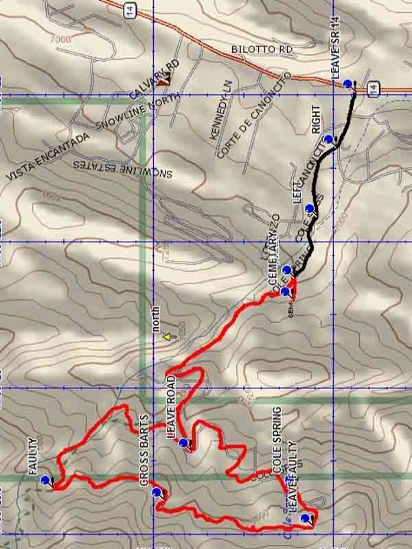
Trailhead DirectionsFrom Albuquerque take I-40 east to Tijeras exit 175. Exit north on SR 14 and go 3.4 miles to LEAVE SR 14 and turn left onto Canoncito. It will be 0 .7 miles to parking from the turn. At the first Y keep RIGHT. At the second Y and the pavement’s end keep LEFT. PARK (0.0 mi) at the locked gate.
Actual HikeThe road and property beyond the gate is private. Please stay on the road and observe the rules posted on the gate. Hike the road and LEAVE ROAD (1.0 mi) to the right, find a trail that doubles back up the hill at a traverse. Along this segment of the hike there will be numerous travertine falls. You will reach the FAULTY (1.8 mi) trail at which point you will take a sharp left onto the Faulty trail which will go south. Follow the trail south, crossing BARTS TRAIL (2.2 mi) trail, and then LEAVE FAULTY (2.9 mi), heading downhill to COLE SPRING (3.1 mi). A nice place for a rest lunch and yes, a spring. From this point re-join the road, going north and downhill until you arrive back at parking. Take the short hike up the side road to the very interesting CEMETARY (4.8 mi), where you might possibly visit some former friends.
CommentsThe travertine falls on this hike are among the best in the Sandias. There is a long succession of pools and small falls along the trail. You will also find alligator juniper in the area. Once on the Faulty Trail encounter the large double bend pine, which is a old trail marker indicating that there is a spring downhill from the trail. At Cole Spring there is a large flowing spring and a number of picnic tables. The trails have good tree cover, providing nice shade in the summer.
This hike is marked inactive because the trailhead using Cole Springs Road is now closed to the public and there is no other nearby access.
The Sandia Ranger District has set a 25-hiker limit for this area.
WaypointsLEAVE SR 14: N35 07.940, W106 21.988
LEFT: N35 08.046, W106 22.414
RIGHT: N35 07.992, W106 22.179
PARK: N35 08.108, W106 22.626
LEAVE ROAD: N35 08.396, W106 23.217
FAULTY: N35 08.781, W106 23.345
BARTS TRAIL: N35 08.472, W106 23.386
LEAVE FAULTY: N35 08.057, W106 23.474
COLE SPRING: N35 08.102, W106 23.342
CEMETARY: N35 08.113, W106 22.700
Hike GPS File Name: Canoncito-Faulty-ColeSpringWayTrack_DBDB.gpx
Hike GPS File: Click link to download hike waytrack file
Text Author: Dick Brown
Map Author: Dick Brown
Waypoints Author: Dick Brown
Track Author: Dick Brown
Maintainer: Bill Gloyd
Editor: Marilyn Warrant