Penasco Springs North Route Hike
In San Ysidro Region
Map File Source: NG Topo
 Hike Key: H10336
Last Updated: 12/15/2020 12:00am
Last Updated By: Marilyn Warrant
Hike Class: C (Challenging)
Hike Distance: 6.2 mi
Minimum Elevation: 5715 ft
Elevation Change: 642 ft
Total Uphill: 916 ft
Total Downhill: 916 ft
Avg. Grade: 6 %
Route Type: Loop
Protected: Yes
On Trail: No
Paved or Gravel Roads: Yes
GPS Advised: Yes
Drive Distance Round Trip: 100 mi
Drive Time One-Way: 1:00
Hiking Seasons: Spring, Fall, and Winter
New Mexico Game Unit: 6A
Hike Status: Inactive
Highlights
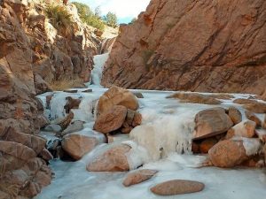
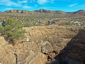
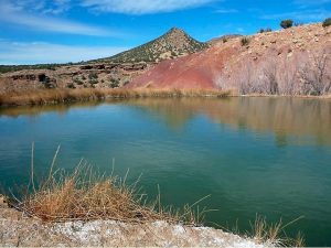
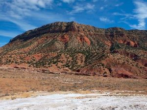
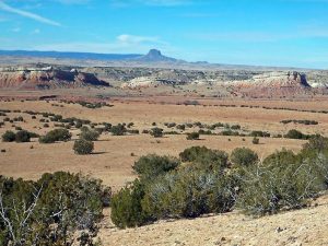
A terrific hike, filled with beautiful and interesting things to see. Views of red cliffs and in the distance White Mesa and Cabezon, white salt deposits, bubbling travertine pools, and a waterfall.
CautionsA few steep sections, so bring your hiking poles.
Trailhead DirectionsGet written permission from Zia Tribal Headquarters, either by the Senior Center or hike leader. To find out the current rules, call the pueblo at 867-2196. They will fax or email the information you will need to provide. Make a copy of their letter; take one copy with you and leave the other in the van. I-25 north to exit 242, west on US 550 to just before milepost 18 (18 mi. past the Bernalillo exit), Zia Pueblo off to right. Go to Tribal Headquarters (ZIA HQ) there (the building with all the vans in back) and ask for the key to the Northwest area. Show them the letter. Drive about 8 miles beyond San Ysidro (just beyond mile marker 31). The gate is on the right, just over the rise and before the bridge across arroyo. Drive through, lock gate, park beyond the next fence below the hill. If gate doesn’t open, park outside and climb gate. Take the letter with you.
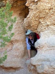
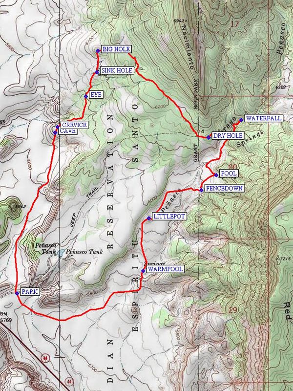
Actual HikeFrom PARK (0.0 mi), begin this hike going North follow an old road along the base of the bluff to your right. At about 0.75 mile, bear right and uphill, then cross the flat and walk uphill to waypoint CAVE (1.2 mi) going left thru the notch to waypoint CREVICE (1.3 mi), where there are several deep fissures in the travertine rock. Now go East Northeast about 0.2 mile, then turn North to a Bus sized rock called the EYE (1.6 mi). There is a passage thru this rock which all newcomers here shall crawl thru for a proper initiation. Old-timers here can carry the first-timers packs around the rock to help them feel a bit better. Continue North to waypoint SINK HOLE (1.8 mi) which is filled with pretty green water, and then climb the travertine knob due North to waypoint BIG HOLE (2.0 mi) which is a huge, deep sinkhole with more green water. Depart here going East, turning Southeast to waypoint DRY HOLE (3.1 mi).You can see the lunch site (circular pond on other side of canyon to southeast) There is a reddish hill to the north of it. Then go east, down into the canyon and follow the water upstream to a (frozen?) WATERFALL (3.5 mi). Go back downstream to lunch site -“swimming POOL (4.0 mi)” spring. Great view of Cabezon Peak. Proceed south to FENCEDOWN (4.2 mi), then west finding a way to avoid the arroyo, if possible. Then follow the canyon bottom south through seeping water areas and two large overflowing domes (LITTLEPOT (4.7 mi) and WARMPOOL (5.1 mi)). From this point continue south and curve around to the west around the south end of the low mesa on your right and back north to parking.
CommentsIt turns out that much of this hike is on the Jemez reservation. You’ll need to get permission from both the Jemez and Zia pueblos in order to do this hike as written.
This hike is set inactive until we get permission from the Jemez Pueblo for the part of the hike that is on their land.
WaypointsZIA HQ: N 35 29.917, W 106 43.776
PARK: N 35 35.393, W 106 52.852
CAVE: N 35 36.369, W 106 52.568
CREVICE: N 35 36.403, W 106 52.550
EYE: N 35 36.588, W 106 52.340
SINK HOLE: N 35 36.736, W 106 52.256
BIG HOLE: N 35 36.865, W 106 52.249
DRY HOLE: N 35 36.339, W 106 51.425
WATERFALL: N 35 36.446, W 106 51.180
POOL: N 35 36.111, W 106 51.365
FENCEDOWN: N 35 36.020, W 106 51.477
LITTLEPOT: N 35 35.849, W 106 51.871
WARMPOOL: N 35 35.531, W 106 51.913
Hike GPS File Name: PenascoSpringsNorthRouteWayTrack_KSKS.gpx
Hike GPS File: Click link to download hike waytrack file
Text Author: Ken Smith
Map Author: Ken Smith
Waypoints Author: Ken Smith
Track Author: Ken Smith
Maintainer: Marilyn Warrant
Editor: Howard Carr