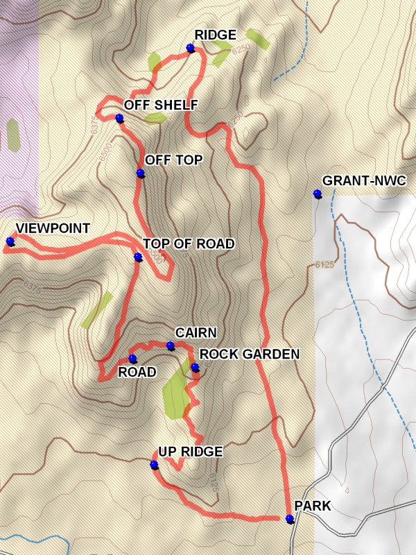
Mesa Cocina Hike
In Tohajillee Region
Map File Source: DeLorme
 Hike Key: H10255
Last Updated: 11/23/2021 12:00am
Last Updated By: Marilyn Fixer
Hike Class: B (Moderate)
Hike Distance: 5.7 mi
Minimum Elevation: 6060 ft
Elevation Change: 460 ft
Total Uphill: 624 ft
Total Downhill: 624 ft
Avg. Grade: 5 %
Route Type: CW Loop
Protected: Yes
On Trail: No
Paved or Gravel Roads: No
GPS Advised: Yes
Drive Distance Round Trip: 100 mi
Drive Time One-Way: 1:45
Hiking Seasons: Spring, Fall, and Winter
New Mexico Game Unit: 9
Hike Status: Inactive
Highlights
Hike to the top of a large mesa with views in every direction.
CautionsThe hike is off trail over sometimes rough terrain.
Trailhead DirectionsFrom Albuquerque take I-40 West to the Tohajillee exit. Go north approximately 5 mi. to the village. Just before school area, turn right over a CATTLE GUARD with yellow sides. Then an immediate left. Drive for approximately 8 mi., taking the obvious main road at any turns. At “T” with another main road, go left for about 4.5 mi. and look for a TURN on the right. After going through the arroyo a “Y” is encountered after some distance. PARK (0.0 mi) on the left just before the Y.
Actual HikeStart the hike by going northwest toward the south end of the badlands formations. An animal path will lead you over the badlands ridge. On the west side of the ridge go north for about 0.2 miles to the UP RIDGE (0.5 mi) point and traverse up to the top of the ridge. Follow the ridge north to the ROCK GARDEN (1.1 mi). Once there take the shelf around to the west past the CAIRN (1.2 mi) and to the ROAD (1.4 mi). Follow the road for 0.5 miles to the TOP OF ROAD (1.9 mi). Stay to the west side of the mesa to a narrow neck which connects the main mesa to the west extension. Go to the VIEWPOINT (2.4 mi) for good westward views. Return across the neck to the main part of the mesa and go to the east side. Go north along the mesa for good views to the east. Go to the OFF TOP (3.3 mi) point. There currently no landmarks identified for this point. There is a faint animal trail at that point which traverses down to the shelf below. There is a road on the shelf. Go north on the road to the north end of the mesa where the road goes OFF SHELF (3.5 mi). The road winds downward to a flat area below. The road disappears at this point, but head northeast across the flat area to the RIDGE (4.0 mi) on the other side where the road reappears. Go up over the ridge into a shallow valley where the road turns south, going up the valley to a saddle. The road then winds downward to the main valley floor. Go southward, staying west of the Canada De Los Alamos Land Grant defined by the point GRANT-NWC to parking.
CommentsAvoid doing this hike during inclement weather. The roads to the hike trailhead deteriorate during wet conditions. The area is very exposed. Dress warmly if doing the hike in early spring or late fall. This is a rough terrain hike. This hike should not be done counterclockwise since the last part of the hike has currently not been adequately researched. The trailhead for this hike is the same as for the Pino Springs hikes.
WaypointsGRANT-NWC: N 35 15.829, W 107 08.069
TURN: N 35 14.737, W 107 08.721
PARK: N 35 14.976, W 107 08.159
UP RIDGE: N 35 15.118, W 107 08.595
ROCK GARDEN: N 35 15.374, W 107 08.464
CAIRN: N 35 15.430, W 107 08.542
ROAD: N 35 15.396, W 107 08.664
TOP OF ROAD: N 35 15.664, W 107 08.647
VIEWPOINT: N 35 15.704, W 107 09.058
OFF TOP: N 35 15.883, W 107 08.639
OFF SHELF: N 35 16.028, W 107 08.707
RIDGE: N 35 16.211, W 107 08.478
Hike GPS File Name: MesaCocinaWayTrack_DBDB.gpx
Hike GPS File: Click link to download hike waytrack file
Text Author: Dick Brown
Map Author: Marilyn Warrant
Waypoints Author: Dick Brown
Track Author: Dick Brown
Maintainer: Not Assigned
Editor: Marilyn Warrant