Citadel – El Malpais Hike
In El Malpais Region
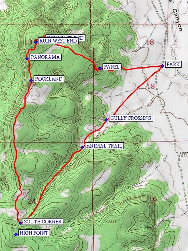
Map File Source: NG Topo
 Hike Key: H10228
Last Updated: 12/15/2020 12:00am
Last Updated By: Marilyn Warrant
Hike Class: C (Challenging)
Hike Distance: 4.8 mi
Minimum Elevation: 7160 ft
Elevation Change: 500 ft
Total Uphill: 710 ft
Total Downhill: 710 ft
Avg. Grade: 5 %
Route Type: CW Loop
On Trail: No
Paved or Gravel Roads: No
GPS Advised: Yes
Drive Distance Round Trip: 200 mi
Drive Time One-Way: 1:45
Hiking Seasons: Spring
New Mexico Game Unit: 13
Hike Status: Published
Highlights
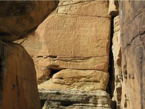
Features a 400 foot long section of ruins, some petroglyphs, and long views. Elk can be seen in this area.
CautionsThe hike is off trail. Poles may be useful.
Trailhead DirectionsFrom Albuquerque take I-40 west for about 70 miles to Exit 89 at Grants. Go south on SR 117 for about 26 miles to a DIRT ROAD on your left. Take that road 3 miles to PARK (0.0 mi) just after the cattle guard.
Actual HikeFrom parking go southwest to the GULLY CROSSING (0.6 mi) where an earth bridge will cross a deep gully. Continue to the beginning of an ANIMAL TRAIL (1.0 mi) and follow the trail up hill. An arroyo bottom will appear on the left. Stay on the south side of the ditch until the land begins to flatten out at the SOUTH CORNER (1.8 mi) at which point turn north. On this segment of the hike you will travel along the top of the mesa. There are good views to the east and west as the top is open and sandy. As you go north tend toward the west edge and after about 1.3 miles at the west side of a rise there will be ROCKLAND (3.1 mi). This is a large collection of very large rocks which one can wander through. Then continue north along the edge to PANORAMA (3.3 mi), where there is a great view which defies capture with a camera. This is a good place for lunch. Then go north to the topmost point ahead. Stay on the west edge of the top and there will be the start of an extensive set of room ruins. The ruins turn and run eastward for about 500 feet. After examining the ruins go east southeast. The land will slope downward. Stay right of the steep drop-off. On the east side of this small cliff there are two very interesting petroglyph PANEL (4.3 mi). Some may wish to forgo them since getting to these panels is somewhat difficult. At the bottom the land will open up and parking will be visible ahead.
CommentsThis hike is located in the El Malpais National Conservation Area, wilderness restrictions apply. This is an off-trail hike. This hike raised to rating C, largely off trail.
WaypointsHIGH POINT: N34 43.639, W107 57.133
PARK: N34 44.871, W107 55.834
GULLY CROSSING: N34 44.477, W107 56.332
ANIMAL TRAIL: N34 44.276, W107 56.542
SOUTH CORNER: N34 43.722, W107 57.093
ROCKLAND: N34 44.764, W107 56.998
PANORAMA: N34 44.925, W107 57.034
RUIN WEST END: N34 45.044, W107 56.958
RUIN EAST END: N34 45.064, W107 56.891
PANEL: N34 44.851, W107 56.389
Hike GPS File Name: Citadel-ElMalpaisWayTrack_DBDB.gpx
Hike GPS File: Click link to download hike waytrack file
Text Author: Dick Brown
Map Author: Marilyn Warrant
Waypoints Author: Dick Brown
Track Author: Dick Brown
Maintainer: Not Assigned
Editor: Marilyn Warrant