Sanchez Canyon Hike
In Santo Domingo Region
Map File Source: DeLorme
 Hike Key: H10211
Last Updated: 12/15/2020 12:00am
Last Updated By: Marilyn Warrant
Hike Class: C (Challenging)
Hike Distance: 4.4 mi
Minimum Elevation: 6464 ft
Elevation Change: 303 ft
Total Uphill: 1063 ft
Total Downhill: 1063 ft
Avg. Grade: 12 %
Route Type: InOut
On Trail:
Paved or Gravel Roads:
GPS Advised:
Drive Distance Round Trip: 120 mi
Drive Time One-Way: 1:30
Hiking Seasons: Spring and Fall
New Mexico Game Unit: 6C
Hike Status: Inactive
Cautions
In the Las Conchas burn scar.
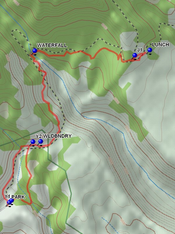
Trailhead DirectionsI-25 north to exit 259. Go west on SR 22 through Pena Blanca, past the Cochiti Dam and the town of Cochiti Lake, where the route number changes to FR 268. Beyond Cochiti Lake town the golf course is on the right. Go one mile past entrance to golf course and turn right on first road (there is an open-sided barn on left). This is FR 289 which sign says “Dome Rd, to St. Rd 4.” A high clearance vehicle is needed. Follow this rocky and rough road for 3.5 miles (20 min.) to a wide spot where the road begins a sharp turn uphill to the left. Dome Wilderness Trail sign is on your right at this turn. PARK (0.0 mi) here.
Actual HikeThere’s an optional loop at the beginning. The trail begins just to the right of the Dome Wilderness Trail sign and forks almost immediately at Y1 (0.0 mi). Take the left fork here to make a loop around the Eagle Canyon. At the far end of this small canyon turn right and find a grey trail signpost at Y2 (0.6 mi). The return loop around Eagle Canyon is to your right. Continue to Sanchez Canyon by heading uphill to your left. You soon come to the wilderness boundary WLDBNDRY (0.6 mi). The trail passes around a notch then descends into Sanchez Canyon. Cross a small stream and a WATERFALL (1.4 mi), and then ascend the far side of the canyon for approximately 1 mile until you reach a trail junction at J1 (2.1 mi). The sign is a bit confusing. Continue straight on the trail toward Turkey Springs (just inside the Bandelier National Monument boundary). (A left turn at the trail sign heads toward St. Peters Dome.) When you come to a crest and start heading down look off to the right for a rock outcropping off into the trees. This is a good LUNCH (2.2 mi) spot with great views. Return as you came until you reach the end of Eagle Canyon. Turn left to complete the loop back to parking. This side of the canyon has much more up and down to it and is rocky, but interesting. A final steep ascent takes you back to the original fork in the trail.
CommentsIn Las Conchas burn scar. Hike set inactive until road verified driveable and hike worth doing.
Great scenery of eroded Peralta tuff with hoodoos like at Tent Rocks. Ponderosa and juniper forest. Overlook at lunch site has nice view of Cochiti Lake to the south and St. Peter’s Dome to the north. We saw wild alfalfa, penstemon, groundsel and evening primrose.
WaypointsPARK: N 35 42.701, W 106 23.065
Y1: N 35 42.713, W 106 23.051
Y2: N 35 43.017, W 106 22.913
WLDBNDRY: N 35 43.018, W 106 22.864
WATERFALL: N 35 43.489, W 106 22.902
J1: N 35 43.466, W 106 22.260
LUNCH: N 35 43.493, W 106 22.164
Hike GPS File Name: SanchezCanyonWayTrack_JBHC.gpx
Hike GPS File: Click link to download hike waytrack file
Text Author: Roger Holloway
Map Author: Marilyn Warrant
Waypoints Author: Howard Carr
Track Author: John Boyd
Maintainer: Vivian Heyward
Editor: Marilyn Warrant