Tent Rocks Hike
In Jemez Mountains Region
Map File Source: DeLorme
 Hike Key: H10193
Last Updated: 12/15/2020 12:00am
Last Updated By: Marilyn Warrant
Hike Class: C (Challenging)
Hike Distance: 3.4 mi
Minimum Elevation: 5740 ft
Elevation Change: 625 ft
Total Uphill: 900 ft
Total Downhill: 900 ft
Avg. Grade: 14 %
Route Type: Loop
On Trail: Yes
Paved or Gravel Roads: Yes
GPS Advised: No
Drive Distance Round Trip: 105 mi
Drive Time One-Way: 1:00
Hiking Seasons: Spring, Fall, and Winter
New Mexico Game Unit: 6A
Hike Status: Published
Highlights
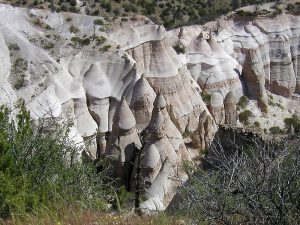
Famous for its tent rocks formations. Hike up a slot canyon and onto the mesa above for a great view of the surrounding area.
CautionsSome steep, rocky sections. Hiking poles recommended.
Trailhead DirectionsFrom Albuquerque take I-25 North to Santo Domingo Exit 259.Go west on SR 22 about 12 miles. At the foot of Cochiti Lake Dam, about halfway along the bottom of the dam, there will be a T intersection on the left. Take the road to Cochiti Pueblo to the Tent Rocks sign on the right. Go right to the entry station. Proceed 6 miles and park in the lot for van parking on the right.
For a single van have one senior pass for each 4 persons in the van to avoid a $25 van fee. For multiple van trips involving 25 or more people a permit must be obtained from the Rio Puerco field office on Montgomery Blvd West in Albuquerque.
Read the posted restrictions. There is a $250 fine for going off trail.
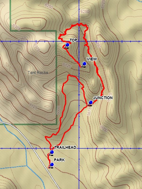
Actual HikeFrom PARK (0.0 mi) go uphill on the cement walkway to the TRAILHEAD (0.1 mi). Stay on the gravel path to a branch and keep right. After about 0.5 miles there will be a JUNCTION with a path going left to the “cave”. Stay straight and you will enter a slot canyon which will have a narrow section. The canyon will then widen and there will be a variety of formations on each side of the canyon. The trail then enters a steep section with stairs, becoming more gradual on top of the mesa. At the TOP (1.3 mi) turn left and go downhill to VIEW (1.5 mi). After enjoying the views of the area return the way you came, going back down and through the slot canyon to the JUNCTION (2.6 mi). The marked trail on the right will take you uphill to the “cave” and more good views from “down below”. The trail turns right and proceeds along the base of a mesa where you get up close tent rocks. The trail meets the outgoing trail near the trailhead. From there return to parking.
CommentsMany years ago tons of ash dropped here from the eruption of the Valles Grande volcano. The compacted ash forms the base of these weird formations and is called tuff. A final splattering of molten lava created denser caps that did not erode. The softer tuff between the splatters, or between ever-widening cracks in the cap rock, eroded away, except under the cap rocks, causing these tent-like formations called hoodoos. The erosion took place over millions of years. Apache tears, small rounded nodules of obsidian, can be found in the gravel along the trails and embedded in the tuff. Looking like raisins, up close they are clear and smoky colored. Comments by Roger Holloway.
WaypointsPARK: N 35 39.410, W 106 24.680
TRAILHEAD: N 35 39.488, W 106 24.665
TOP: N 35 39.969, W 106 24.589
VIEW: N 35 39.881, W 106 24.491
JUNCTION: N 35 39.700, W 106 24.454
Hike GPS File Name: TentRocksWayTrack_DBDB.gpx
Hike GPS File: Click link to download hike waytrack file
Text Author: Dick Brown
Map Author: Dick Brown
Waypoints Author: Dick Brown
Track Author: Dick Brown
Maintainer: Joan Weissman
Editor: Howard Carr