Santa Fe River Mesa Hike
In Santa Fe Region
Map File Source: NG Topo
 Hike Key: H10186
Last Updated: 12/15/2020 12:00am
Last Updated By: Marilyn Warrant
Hike Class: C (Challenging)
Hike Distance: 5.5 mi
Minimum Elevation: 5980 ft
Elevation Change: 240 ft
Total Uphill: 670 ft
Total Downhill: 670 ft
Avg. Grade: 6 %
Route Type: Loop
On Trail: No
Paved or Gravel Roads: No
GPS Advised: Yes
Drive Distance Round Trip: 100 mi
Drive Time One-Way: 1:15
Hiking Seasons: Spring and Fall
New Mexico Game Unit: 6C
Hike Status: Published
Highlights
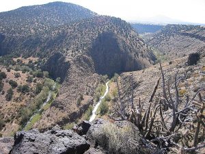
360 degree views from the mesa, including the Santa Fe River valley. Lava rock formations.
CautionsWill need to ford stream; some steep sections so bring hiking poles.
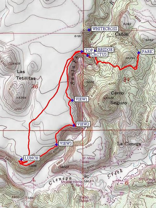
Trailhead DirectionsTake I-25 North to exit 271 (La Cienega). From the Frontage road, turn left and go over I-25 heading NNW into La Cienega on Santa Fe County Rd 50F (SR587). At a Y intersection at ENTRADA go right. Take a right onto CR54, and a quick left onto CR54B. Go less than a mile on CR54B, turn left on CR54A, then go a short distance to PARK (0.0 mi). The trail starts there and goes up the hill in front of you.
Actual HikeFrom parking, head up the trail, then down to the river. Find a place to cross. After crossing the river, passing some CACTUS (1.0 mi), and climbing to the TOP (1.0 mi) of the mesa walk south along the edge to the end of the mesa. There are great views (VIEW1 (1.7 mi), VIEW2 (2.0 mi), and VIEW3 (2.4 mi)) of the surrounding hills and especially of the dramatic canyon gorge below. You’ll see an acequia system that required a lot of effort on the part of ranchers in the valley. At the end of the mesa, have LUNCH (2.9 mi) and enjoy the view. After lunch retrace your steps or take the easy way and go north and then northeast along a dirt road to rejoin the trail at TOP.
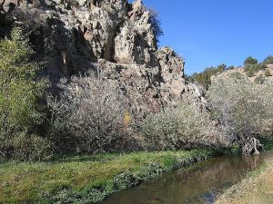
CommentsIn Santa Fe, the Santa Fe River is often dry. By the time it gets down to here though it can have quite a bit of water in it. Caution: Don’t schedule this hike unless you’re willing to ford the stream, build a new bridge (the old one was destroyed in the rains of Sept 2013), or verify that you can cross on stones.
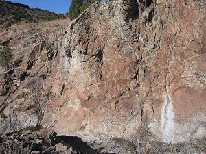
The hike class has been raised to a C because of the rocky trails (and off-trails).
WaypointsAccess
CR54: N35 33.951, W106 07.563
CR54B: N35 33.914, W106 07.682
ENTRADA: N35 33.649, W106 07.561
EXIT 271: N35 33.049, W106 07.322
SR587: N35 33.264, W106 07.203
WHITECROSS: N35 34.835, W106 08.430
Hike
PARK: N35 34.631, W106 07.883
BRIDGE: N35 34.649, W106 08.370
CACTUS: N35 34.607, W106 08.444
TOP: N35 34.640, W106 08.508
VIEW1: N 35 34.205, W 106 08.615
VIEW2: N 35 33.981, W 106 08.596
VIEW3: N 35 33.810, W 106 08.785
LUNCH: N 35 33.676, W 106 09.170
Hike GPS File Name: SantaFeRiverMesaWayTrack_MWBG.gpx
Hike GPS File: Click link to download hike waytrack file
Text Author: Marilyn Warrant
Map Author: Marilyn Warrant
Waypoints Author: Bill Gloyd
Track Author: Marilyn Warrant
Maintainer: Marilyn Warrant
Editor: Howard Carr