Capilla Peak South Hike
In Manzano Mountains East Region
Map File Source: Roger Holloway
 Hike Key: H10152
Last Updated: 12/15/2020 12:00am
Last Updated By: Marilyn Warrant
Hike Class: B (Moderate)
Hike Distance: 4 mi
Minimum Elevation: 0 ft
Elevation Change: 500 ft
Total Uphill: 640 ft
Total Downhill: 640 ft
Avg. Grade: %
Route Type: InOut
On Trail:
Paved or Gravel Roads:
GPS Advised:
Drive Distance Round Trip: 130 mi
Drive Time One-Way: 2:00
Hiking Seasons: Spring, Summer, and Fall
New Mexico Game Unit: 14
Hike Status: Inactive
Cautions
None.
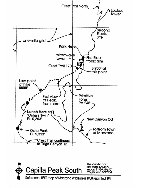
Trailhead DirectionsI-40 east to Tijeras exit 175. South 30 mi. on SR 327 to end. Right (west) on SR 55 to Tajique, Torreon and Manzano. Turn right at north (near) end of the church in Manzano onto (probably unmarked) FR 245. Should be sign for New Canyon CG. Road goes north, then northwest, then becomes primitive. You will pass New Canyon CG (pit stop?) and eventually the trailhead at the first electronic site. This is the only road that goes to the crest. Follow Crest Trail 170 south to Osha Peak and return. Note: We don’t really go to Osha Peak but to the peak just before it which is only 20′ lower. Let’s call it Osha Twin. You can see it from the road as you approach because it has much bare rock exposed–unlike surrounding areas.
Actual HikeThe trail starts off going uphill from the left (east) side of microwave tower, but then it is a long, gradual descent. You will come to a place where you can see Osha Peak Twin ahead of you, but the trail doubles back and continues down a ridge a long ways before you start to make a lot of switchbacks to the top. You can have lunch at the top with views in all directions.
CommentsInactive. FR 245 from New Canyon Campground to Capilla Peak must reopen and someone must verify that the hike is still worth doing (fire damage etc.) before this hike should be reactivated.
We’ve seen deer, wild turkey, squirrel. On 8/01 we saw two skunk. There is a 40 min. drive on primitive road from town of Manzano to parking spot on Capilla Peak. The primitive road up there is part of the adventure with lots of scary switchbacks.
WaypointsCapilla Peak TH: N34 41.318, W106 24.546
Map Filename: CapillaPeakSouthImage_RH.jpgHike GPS File Name: CapillaPeakSouthWayTrack_00MW.gpx
Hike GPS File: Click link to download hike waytrack file
Text Author: Roger Holloway
Map Author: Roger Holloway
Waypoints Author: Marilyn Warrant
Track Author: Marilyn Warrant
Maintainer: Not Assigned
Editor: