Calaveras Canyon Hike
In Jemez Mountains Region
Map File Source: DeLorme
 Hike Key: H10074
Last Updated: 09/05/2023 3:17pm
Last Updated By: Marilyn Warrant
Hike Class: B (Moderate)
Hike Distance: 5.4 mi
Minimum Elevation: 8100 ft
Elevation Change: 300 ft
Total Uphill: 300 ft
Total Downhill: 300 ft
Avg. Grade: 3 %
Route Type: InOut
On Trail: Yes
Paved or Gravel Roads: Yes
GPS Advised: No
Drive Distance Round Trip: 168 mi
Drive Time One-Way: 2:00
Hiking Seasons: Summer and Fall
New Mexico Game Unit: 6A
Hike Status: Published
Highlights
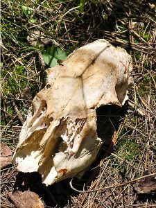
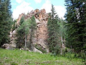
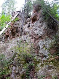
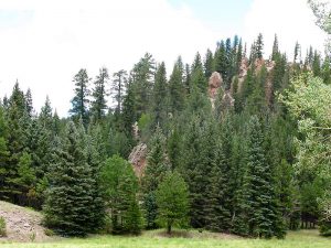
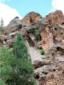
The hike follows a grassy canyon bottom with dramatic craggy rocks, mushrooms and flowers. Some of the rocks have “Swiss cheese” holes in them, making them look like faces.
CautionsNone.
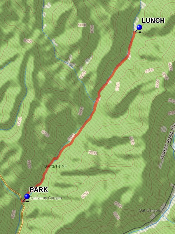
Trailhead DirectionsFrom Albuquerque take I-25 North to Bernalillo, US 550 west to San Ysidro, SR 4 north to La Cueva, left (west) on SR 126. Once Fenton Lake is reached, it will be 4.0 miles from the end of the bridge which crosses the marsh to parking. Go past the turnoff to Seven Springs and cross a couple of bridges then look for the refurbished parking area on the right that now could hold 3 vans easily. PARK (0.0 mi) there.
Actual HikeGo through the fence and follow the wash down to a 6″ pipe and go left along the pipe. A dirt road will take you up a hill where there is a gate. When you come down you will come upon a Water Quality Control project by UNM with many “mushrooms” of pvc pipe and a weather station. After about a mile, a rock formation that looks like a castle tower will appear. Perfect Christmas trees of blue spruce abound. A striking feature of this hike is the Spanish Moss (“Old Man’s Beard”) hanging from the trees like slender chiles or icicles. Hike follows grassy canyon bottom with dramatic craggy rocks, mushrooms and flowers. There are several side canyons to explore. There are a couple of gates to open. Make sure to close them. Some of the rocks have “swiss cheese” holes in them, making them look like faces. Maybe this is why it is called Skulls Canyon. One of the faces, about a mile in from the road, looks like a skull from the front, but like a gorilla or ape from the side. Go up the canyon until you find a nice place to have LUNCH (2.7 mi).
CommentsThe canyon extends much further than we will have time to hike. After about 4 miles up the canyon FR 263 would be reached.
WaypointsPARK: N35 56.462, W106 42.390
LUNCH: N35 58.256, W106 40.913
Jemez Falls Bathrooms: N35 46.313, W106 41.444
Hike GPS File Name: CalaverasCanyonWayTrack_DBDB.gpx
Hike GPS File: Click link to download hike waytrack file
Text Author: Roger Holloway
Map Author: Marilyn Warrant
Waypoints Author: Dick Brown
Track Author: Dick Brown
Maintainer: Dawn McIntyre
Editor: Marilyn Warrant