Mesa Penistaja Hike
In Cuba Region
Map File Source: DeLorme
 Hike Key: H10047
Last Updated: 12/15/2020 12:00am
Last Updated By: Marilyn Warrant
Hike Class: C (Challenging)
Hike Distance: 5.9 mi
Minimum Elevation: 6975 ft
Elevation Change: 225 ft
Total Uphill: 535 ft
Total Downhill: 535 ft
Avg. Grade: 5 %
Route Type: Loop
Protected: Yes
On Trail: No
Paved or Gravel Roads: No
GPS Advised: Yes
Drive Distance Round Trip: 190 mi
Drive Time One-Way: 1:45
Hiking Seasons: Spring, Summer, and Fall
New Mexico Game Unit: 7
Hike Status: Published
Highlights
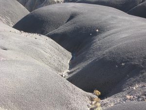
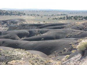
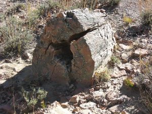
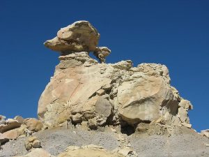
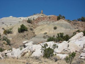
Black badlands and white rock formations; petrified wood.
CautionsThis hike is off trail over sometimes rough terrain
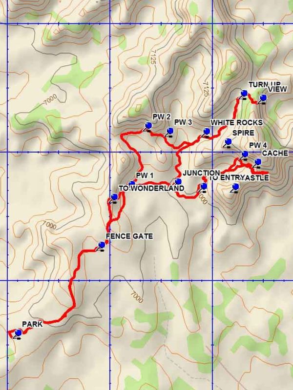
Trailhead DirectionsFrom Albuquerque take I-25 north to Bernalillo. At Bernalillo take US 550 west to the intersection with SR 197 in Cuba. Turn left and drive 9 miles to the DIRT road at the bend in SR 197. Turn right onto the dirt road which immediately turns left and heads west. Drive 7.2 miles to LOVINO WOODS road on the right. Turn right and go 1.6 miles to a two track on the right side of the road. PARK (0.0 mi) here, or take the two track as far as desired. The road is rough in spots.
Actual HikeFrom parking take the two track to the FENCE GATE (0.7 mi). Along this segment of the hike there will be black badlands formations on the right and below the two track. Look for the fence gate, which is simply a set of fence wires which can be detached. Pass through the fence at this point and head northwest of about 0.2 miles to the edge of a sloping drop off at the TO WONDERLAND (0.9 mi) point. Drop down into the arroyo and go north. Stay near the east edge of the arroyo. There will be a number of pieces of petrified wood strewn about at PW 1 (1.1 mi). Other PW points are identified, but only indicate a few of the locations where petrified wood is found. Some pieces are quite large, and small fragments are everywhere. Turn to the east at the cliff barrier and work west along the base to the WHITE ROCKS ENTRY point. Go northwest up the arroyo, which is lined with a profusion of white rock formations. The arroyo will become very narrow. After about 0.4 miles of travel TURN UP (2.2 mi) right out of the arroyo, going upward. Go about 0.1 mile, aiming for the left side of the peak ahead to the VIEW (2.3 mi) point. This is a good place for lunch. Return the way you came. After leaving the white rocks area stay in the main arroyo going south to the JUNCTION (3.1 mi). Then turn left toward the ENTRY point. This arroyo will become narrow before opening up into a large box canyon. There are many interesting features in the canyon. Go toward the end of the canyon to the CACHE (3.6 mi) location. Going up the end of the canyon is difficult, although there is a good view beyond the cache point. Return the way you came to the JUNCTION but continue eastward to the low hill descended previously and go up to the inbound track. Return the way you came to parking.
CommentsExcept for the access two track, the hike is off-trail over rough terrain.
WaypointsCASTLE: N35 59.345, W107 12.417
DIRT: N35 57.382, W107 05.520
LOVINO WOODS: N35 57.424, W107 13.180
RIGHT: N35 57.423, W107 13.182
SPIRE: N35 59.522, W107 12.453
PARK: N35 58.777, W107 13.479
FENCE GATE: N35 59.119, W107 13.071
TO WONDERLAND: N35 59.306, W107 13.010
PW 1: N35 59.355, W107 12.925
PW 2: N35 59.584, W107 12.844
PW 3: N35 59.562, W107 12.739
WHITE ROCKS: N35 59.561, W107 12.558
TURN UP: N35 59.710, W107 12.376
VIEW: N35 59.691, W107 12.282
JUNCTION: N35 59.365, W107 12.698
TO ENTRY: N35 59.347, W107 12.573
CACHE: N35 59.443, W107 12.309
PW 4: N35 59.473, W107 12.372
Hike GPS File Name: MesaPenistajaWayTrack_DBDB.gpx
Hike GPS File: Click link to download hike waytrack file
Text Author: Dick Brown
Map Author: Dick Brown
Waypoints Author: Dick Brown
Track Author: Dick Brown
Maintainer: Bill Gloyd
Editor: Marilyn Warrant